
 |
| Tailing over a super rocky trail. (I'm holding the rein on Lily's left side; it is not going through her legs) |
Actually, both of them are!
 |
| Check out Charles's big goofy grin. :D Gracie tackled that trail barefoot like NBD. Yes, the rocks behind them are the trail. |

And Gracie recovering on hill sets so well that we decided it was time to try something more challenging.
Since Charles was off work and available this past weekend, we planned on hauling out on our own for the first time ever. We were going to go to Sugarloaf Mountain...no, North Tract...no, Little Bennett Regional Park...no, Annapolis Rock...no, the Antietam Battlefield! We wanted to go somewhere safe but not too far. North Tract was my #1 choice because you check in and out of the park so someone knows you're there and whether you made it back out, and the trails are awesome! For anyone local interested in trail riding, North Tract's trails were originally built for military tanks: they are WIDE and dry. Excellent for riding after heavy rain or during winter when trails in this region tend to become a frozen muddy mess. Plus both mares and I have already been on them, so it was familiar territory and it's not a terribly popular section of the Patuxent River State Park (North Tract is part of the Patuxent), which meant we could avoid the Mother's Day crowds. Except it is about 90 miles from our neck of Frederick! That was too far for our maiden voyage. Sugarloaf Mountain was closest and had a more challenging trail but I knew it would be crowded: it's a very popular hiking area, in part thanks to the Sugarloaf Mountain Vineyard, which is open for the season and has activities almost every weekend in the summer. Little Bennett was next in closeness but one wrong turn trying to get to the horse trailer parking area and you can end up having to take truck and trailer through a river! Kathy can tell you all about it: she got the truck and trailer through the water on our first adventure there! It's been long enough since we went that I didn't feel 100% confident I'd remember the correct route. So Annapolis Rock? It's farther away. Not as far as North Tract, but still far. And the trails take you right into the Patuxent, which is "only" 6,700 acres, criss-crossed throughout with a spiderweb of unmarked trails. I love the Patuxent but God forbid something happen to you in the middle of it because there is no way to describe where you are. The Antietam Battlefield was actually closest of all of the options we were considering and we had finally decided on just going there even though the trails were going to be easier...until I read that horses are allowed on all the paved roads and maybe 4 miles of trails. Plus I suspected it was going to be BUSY with it being Mother's Day and the promise of a beautiful, hot sunny day. Battlefields are popular tourist attractions in this area. Plus we didn't need to haul out if we wanted to do a short trail ride and ride on roads. We could do that from the barn. (Feel free to click on all of those links: some take you to information on the parks and some to previous posts about my experiences riding at the ones that I've visited.)
So literally at 11:00 pm on Saturday night, after we discarded the idea of riding at Antietam as well, I sat down to scour through TROT's website for available horse trails in Frederick County, which led me to this website...and that's how I came upon Gambrill State Park, which I had never heard of. Charles had found it on the map while mapping out all of these routes too and it was even CLOSER than Antietam...it was a 20 minute trailer ride and they have 16 miles of trails, of which 15 allow horses. Trails are described as "moderate to challenging." BINGO!
There is a warning on the website for horseback riders that parking is limited. Thank God for that warning because that was a big motivating factor in us arriving early.
We had been planning on being at the barn by 8:00 am and had left the trailer completely packed and ready on Saturday. We just had to hitch the trailer, get the girls from the field, give them something to eat, and load them up. We got there 10 minutes early, pulled the horses, and Lily got alfalfa and Gracie had her grain with joint supplement and Previcox (she will eat hay on the trailer, Lily won't), while I hammered Lily's Gloves onto her fronts with a mallet. Gracie loaded up easily, especially for her, and Lily self-loaded as usual. Off we went!
We arrived at the Trailhead Parking Lot (all the Gambrill trails lead out from, and return to, this lot and it's the one that allows horse trailers) at about 9:15 am. There were maybe 6 cars but the parking lot was indeed small and it took a minute for us to decide where would be the best place to park where we would only take up 1-2 spaces without running the risk of getting boxed in by a car parking in the space opposite us.
We ended up parking at the far end of the lot, right next to the entrance to the Yellow Trail but not blocking it. Charles maneuvered it so that there was half a car space between the truck and the parking lot fence and at a slight angle so that he could back the trailer onto the Yellow Trail entrance to get out if we did happen to get boxed in.
The parking lot started filling up rapidly as we tacked up. The girls got to eat more hay while we got them ready. There were people with dogs that were thankfully on leashes, families with small children, and bikes. Neither mare was disturbed in the slightest by the growing commotion and I will praise this state yet again: most people that we have met on trail with the horses in MD either have horse knowledge or are well-informed enough to know how they should behave around them. I never cease to be impressed. A guy showed up in a Miata and the only available parking space was behind the trailer. He asked if it was okay if he parked there. We said of course: it would be easy to maneuver around a smaller car! We thanked him for asking. Our two horses were heavily complimented by passers-by. One mother and her little girl walked past and the little one wanted to pet the horsies. They stopped at a safe distance and asked for permission. Charles, ever the people person and the one that is used to working with children, invited them to pet Gracie. He warned about her feet and her teeth and told the little girl that the best place to touch the horse was her shoulder. Gracie kept on quietly munching from her haynet. The little girl was beaming and her mom thanked us before they walked away again.
 |
| Lily does a good imitation of an old plug when she wants to. This is how she normally is when trailering out (well, normally since starting with all of the endurance training almost 2 years ago; she used to be a nutjob) and it was good to see that she was still like this. We hadn't trailered anywhere other than for endurance rides or to move barns since last summer. |
 |
| Charles getting ready to mount up. A gesture every rider does when gathering the reins before mounting up and one that it has taken me 6 months to drill into him...no need to remind him anymore. And that's what the Alta looks like without its sheepskin cover. :) It's a grippy nubuck and suede combo. The Ortho Flex needs new billets on one side so he's riding in my saddle for now. I 've been using the Wintec with Lily. |
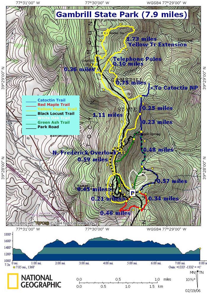
I had looked at the trail map online multiple times the night before and on the drive to the barn and later the park, enough to know where the White Oak Trail was so we could avoid going on it: it is the only one where horses are not allowed. I also knew that all of the trails looped back into this parking lot, which is also why I wasn't particularly concerned about going out wherever as I knew we would eventually be taken back to the trailer. Plus both Lily and Gracie have a fantastic ability for taking us back to the trailer when given the opportunity, a fact that I have had the opportunity to put to the test in the past with both horses.
Here is a topographical map I found online for you guys, so you can have an idea of the route we would be taking.
 |
| A link to this same map, which might let you see a larger version, can be found here. Detailed trail routes can be found here. OF COURSE I found that website AFTER we rode at the park, while doing additional research for the blog... |
I failed to notice, though, that the Yellow Poplar Trail has two loops: an Upper and a Lower. I also failed to notice that it is the longest of the trails, which would be an important fact later on. I really wish they had paper maps at the information stands throughout the park; we stopped at more than one looking for a paper map we could carry and found none. Next time I'll be printing out a trail map beforehand.
For those of you that like hearing my island stories, I will tell you a quick reason why I usually simply have no patience for maps unless I need one Right Nao: back when I lived in Puerto Rico, phones were just starting to have cameras in general in the early 2000s so none of them had GPS. If you wanted to own your own GPS, you had to be willing to spend several hundred dollars to buy one. I didn't feel the need to spend that much money on an electronic device at the time when I was perfectly capable of reading a map. Which served us well when on expedition with my dad on the awesome trips he took us on in the wilderness of Lake Tahoe, CA and Yellowstone Park, WY, and is thus how I got anywhere on the island. Let me tell you, the wonderful thing they do here in the continental US where roads criss-cross perfectly in a grid? That does not happen on the island. Roads might seem to be parallel and to connect with cross streets but they never will. They'll just take you sideways up a mountain or you'll end up on a beach. Eventually. (Because the great thing about living on a small island is that you can find a beach almost 30 minutes from anywhere. And you'll never end up in a place that is not the island. So there's that too.) Numbered roads are not in ascending or descending order like they are here. And streets have names according to the island maps but good luck finding a physical sign to tell you a street's name, especially when you're in some parts of the suburbs or in full-blown country. Add to that the fact that the island is in a constant state of development and I don't think even monthly GPS updates could keep up with the constant new roads, routes, side streets and neighborhoods. One day PR is just going to be a concrete block in the ocean, I swear. It's 100 miles long x 35 miles wide with a population of 3.5 MILLION. It is the most densely populated country in the world. My hometown, Guaynabo, is not a small town. The population of Guaynabo alone is 97,000 (and that's down from when I lived there...in 2004 when I moved to the US, Guaynabo's population was 100,000). So you can understand how wonderful it was that my family lived in this tiny little oasis of green in the middle of all that city. (And it also gives you an idea of how truly awesome my horse was that I could ride him anywhere.) So maps: I used maps to get to places I'd never been to before but accepted the fact that I would probably only end up in the general vicinity of where I wanted to be and that I would most likely be stopping at a gas station somewhere to get specific directions, where I would be told to make a left at the house with the big flower garden in front, a right at the Burger King and another right at the intersection with a Texaco on the left (not a single street name or number used in those directions, btw. You just paid attention to landmarks. And to the direction the person giving you the directions was pointing with their hands while talking, because they were invariably opposite of what they were verbally telling you. You went by the hand gestures. I'd love to say I'm exaggerating but I'm not). Hence my love/hate relationship with maps. Charles is an Eagle Scout who knows how to make a compass using a bowl of water, a leaf and a sewing needle. We will disregard the fact that we had no sewing needle with us and that, anyway, as Charles himself will tell you, "No sewing needle will always point North because they are not made out of pixie dust."
We did, however, have full bars on both our fully charged cell phones (we have Verizon, which is better than Sprint in this region but still not as good as AT&T) AND I had the good sense to put fresh batteries in my Garmin.
Which leads us back to Sunday.
I chose to lead all of the way. G-Mare likes to lead periodically but when she decides she is done leading, she will make a quick 180 turn into the horse behind her, a terrible habit I have not been able to curb yet. She's gotten so much better overall but this habit is incredibly annoying when she decides to do it, and I didn't want her doing it on a narrow, rocky mountain trail.
The Yellow Poplar Trail took us up up up a narrow little trail on the side of the mountain that I pointed out to Charles as something similar to what you would encounter at the OD in terms of narrowness and steepness next to us. We had a guard rail and a road above us and eventually the trail came even with the road and took us across it.
 |
| Section near where trail met the road. Note the guard rail on the left. |
The huge rock slab at the beginning of this video reminded me a lot of one section of trail at RBTR...Dom will know which section I'm talking about! Lily went up the side of it not unlike Griffin and Magic Man did at the WV ride.
A nice feature of this section of trail were the "steps" made up of sideways logs every few feet.
 |
| You can kind of see them in this photo. We were going downhill here. In some sections the "steps" were quite steep and Lily lunged up them like an event horse up a series of low banks. |
 |
| This was at the highest point of the Black Locust Trail. The cabin on the right is rentable for activities. |

We had a grand time following the signs on this trail, which took us farther away from other hikers/people in general but eventually took us back up to the road. We found the Knob Hill visitor's center and scenic point but the view was harder to see while on horseback from here. We crossed the road then back again and made our way back onto the trail
 |
| High Knob visitor's center. Two water fountains and a restroom here, plus a spigot that could've been used to fill a bucket. Note to self: buy collapsible water bucket. |

 |
| I think this gives you a better idea of how high up we were. |
 |
I didn't ask her to get closer to the edge in case she decided maybe I wanted her to jump over it...it was a pretty steep loooooooong drop on the other side of that stone bench wall... Charles fueling up on some Gatorade and Gracie looking annoyed that we'd stopped. |
 |
| I didn't get pics of the truly rocky parts because I was too busy trying to help my horse negotiate them. |
 |
| This is the part where Lily said, "Seriously? THAT'S the trail??!" |
 |
| Because rocks. |
 |
| And logs. |
One of the nicer sections of trail.
But no worries! We knew the trail would eventually take us back to the parking lot so we continued on into the Upper Loop of the Yellow Poplar Trail which signs indicated added an extra 2.5 miles to our hike. We spotted the sign indicating this added mileage as we came even with powerlines and trail running underneath the powerlines on either side. Lily said, "Oh let's go this way!" and tried to go left at the power lines but I told her that we must follow the Real Trail.

We had gone about 5 slow miles by then so 7.5 miles wasn't a bad thing. Lily was pretty enthused about continuing on our way anyway and I was still entertaining the idea of crossing the parking lot once we made it back and adding at least one of the other trails to our day's ride.
It was hard to trot. The further along the Upper Loop we went, the slower our walk became as the trail got narrower and narrower as it wound its way through the trees. I felt like I was constantly contorting myself around the branches to avoid getting hit in the face or banged in the knees. The trail was often just narrow enough for the horses to get through with barely any room for legs and tack around them.
 |
| Decapitator branches at eye level, as you can clearly see in this photo Charles took! |
This video doesn't really do justice to the narrowness of the trail but you can see how low the branches were in some sections. It was all perfect for mountain bikers but not necessarily horseback riders.
There were no people at all in this section of trail, other than a man in a white shirt and hiking pants that went past us going in the opposite direction. I eventually dismounted. I was starting to worry about the time we'd been on trail + the fact that there seemed to be no natural water sources anywhere whatsoever. Stuff that in the past I wouldn't have worried as much about but this is what happens when you become an endurance rider. It was a hot and humid day, both mares were sweating even with the slow pace and we were deep enough into the woods that there was no grass growing anywhere. I told Charles that as soon as we came upon grass, we needed to let the horses graze. Of course I had brought an entire first aid kit with us but completely forgotten to bring baby carrots for the girls, which would have been a nice treat for them right around then. I had originally thought to electrolyte them prior to heading out but was now glad that I hadn't, given the lack of water.
I led Lily through the woods, Charles following behind on Gracie. It was awesome to stretch my legs out as my sciatic nerve on my left leg (the side with the bad hip) was pretty angry from all of the maneuvering I'd had to do in the saddle. I was thrilled to be wearing my hiking boots right about then as the rocks on the trail made for some tricky footing. The good part was that inclines were not steep and were quite easy to climb up or down. It gave Lily a break from both having to carry me and from leading.

 |
Going downhill And through a gorgeous fern forest. |

 |
| All green. All fern. No grass. |
Lily looked one way and then the other, seemed to think about it, and turned left.
Lily followed the trail back to the road and turned left again, following the road. I knew she would certainly take us back to the parking lot through the shortest route possible. The first time I ever got truly lost with her in the woods was when we went to Annapolis Rock with Carol and Katie. I let Lily choose the way and she simply took us to the road. At the time I didn't recognize the spot and made her turn back into the woods to find an alternate route through there....later when we were leaving the park in the truck with trailer in tow, we drove past the spot that Lily had taken us to...it was literally around the corner from the trailer parking lot: she had been 100% absolutely correct and had been taking us through the shortest way she knew.
Now, someone tell me how this horse knows that a road can be a shortcut and/or that she must follow a trail to get to a specific point. How does she know to not just cut cross country through the woods, which would probably be the most direct route of all? I ponder these things and have no answer. It's not like she's been a trail horse her entire life either.
While I was relieved that at least one of us knew where we were going, I was not comfortable riding on the side of the road for x number of miles. I wasn't sure if it was allowed, for starters, and secondly, we had seen and heard plenty of motorcycles whiz by when the trail had taken us close to the road. The horses had not been bothered by the motorcycles at all then but I figured it might be an entirely different story to have an ear-splitting noisy small motorized vehicle blast past us at 90 mph only 4' away.
So to Lily's chagrin we turned around and I directed Lily back onto the trail that I thought would eventually take us in the direction she wanted to go. Except I got the feeling that now we were officially going around in a circle. In utter frustration, I pulled out my phone and set the address for the park parking lot in the phone's map app. Indeed: we were going in the opposite direction!
Two hikers walked past us then and Charles stopped them to ask which direction was the parking lot. They didn't understand Charles's question and he had to repeat himself. When they responded, they both had heavy accents. They said we were headed in the right direction. When Lily told me she wanted to turn around and follow them, I got the impression that there had probably been a language barrier in the response we had just been given, as it was still opposite of what both the GPS and Lily were saying...but Charles insisted we continue on in the direction we had been told.
At this point we both dismounted and hand-walked the mares a mile or so. I was having a hard time deciding if Gracie was bored with following or getting tired. Charles felt it was a mix. We finally found a patch of grass on the trail and stopped to let the horses eat for a while. They both perked up significantly after the snack.
 |
| Sparse grass but better than nothing. |
 |
He tends to rest his hands on the pommel when walking. And he has a talent for awkward photos... Like this one. He knew I was taking the photo, too. I asked him, "What were you looking at?" "I dunno. The trees!" Still better than all the other ones I have of him pushing up his glasses, which half the time make him look like he's picking his nose! |
We turned around and trotted back up the trail as far as we could go at speed, until it became narrow and twisty-turny around the trees over rocks again.
I might have felt like screaming over the idea of doing the entire trail backwards all over again, but it was good to know where we were going! Both mares were quite pumped to go at a faster speed in what they knew was the correct direction. :)
We came at another fork in the trail and Lily indicated that we should go left so I let her. This path was actually wider than the main trail and we all picked up a canter, following this new trail to where it dead-ended next to an abandoned cabin in the middle of the woods. We didn't pause: we swung both horses around and hightailed it back out of there as quickly as we had arrived!
Once back on the main trail, we realized that this small detour had been enough to put us behind the nice man in the white shirt that had given us correct directions. I felt like it would be rude to blast past him at a trot after all that, so we hung back at a walk. I eventually dismounted again as we came to the very rockiest portion of the trail.
Lily wanted to walk in front of my shoulder so I unclipped the reins, wrapped her tail around one hand and asked her to go in front. She gave me one confused look then moved on when I asked again. Charles snagged this series of photos.


Again, she never ceases to amaze me.
Soon we started recognizing more and more landmarks on the trail and started coming across more people. It wasn't long before we came to the final road crossing that would take us back to the parking lot. For this I remounted and walked/trotted the majority of the rest of the way back to the parking lot path.


We dismounted when we were within sight of the parking lot. I was relieved to see this:
 |
| No one had boxed us in! :D |
We had completed 9 miles in 3 hours and 10 minutes.
Around then, a mother and her two young daughters showed up. The mother said hi and Charles went through his spiel of explaining to the little ones where it was safest to touch a horse. Mom added to the explanation, then told us she has horses herself. So we all got to talking horses while the youngest of the two girls stared in utter adoration at the two mares. Lily sweet as always, turned and nuzzled both girls with her mash face. They didn't care. Mom was very impressed by the horses' behavior. We got back during a lull in activity which is why there are no people in the photo above, but there were now hikers, cyclists, people with their dogs on leashes, and both horses continued eating peacefully. The mom complimented the girls for being so calm and us for letting her daughters touch our horses.
After that we loaded up. Gracie was a little reluctant to bring her hinds onto the trailer, which is normal for her if she's at all tired after an off-property trail ride. She hopped on when Charles simply held a dressage whip pointed at her butt. Lily went on with no problem.
It was an uneventful drive back home. We had SO much fun despite getting lost and hope to visit Gambrill State Park again in the near future!

"I'll pick up the dog" LOLOLOLOLOLOLOLOLOLOL
ReplyDeleteI think that was my favorite part you hadn't already told me in texts.
It was HILARIOUS to see in person! This tall thin guy carrying his dog belly up. The dog looked like he was in heaven! I told the guy, "I think he's a little too comfortable!" The biker agreed.
DeleteCongrats on the trailer and first outing. The freedom with your own trailer is awesome and it sounds like you have a ton of options close by. It seems like your summer is going to be a great one.
ReplyDeleteI hope so! Thank you Sara! :)
DeleteCollapsible water buckets are a must, especially when riding in parks. I bought one for the East-West Regional trail, but haven't had a chance to use it on trail. I have one similar to this. It will fold and fit in the cantle pack or hydration pack.
ReplyDeletehttp://www.amazon.com/dp/B001F1WNAI?psc=1
That trail was gnarly. I'm not sure I would be willing to go back. And I'm pretty sure I would have stayed to at least investigate the abandoned cabin (I love old buildings). And yes, I would have been killed in any horror movie you would choose to name. I think they predicted I would last three hours in a zombie apocalypse.
The photos are awesome and I'm really glad you had a great time!
The cabin was actually not that old but the door was wide open and there was a couch inside that had been obviously gutted and ripped apart. I don't know if it's a cabin that people can rent (there are campgrounds at Gambrill) but it was literally in the middle of nowhere, with only that trail leading up to it, and super eerie to find in that sorry state. Charles would've been more than happy to stay and explore, but I was all, "WE ARE GETTING OUTTA HERE!" Yup, he too would've been killed in any horror movie! When we watch horror movies he's all, "Oh man, they're going in that creepy house! I would so totally do that!" and I'm always like, "NOOOOO WHYYYYYYY!" Hahahaha...
DeleteGlad you enjoyed the photos! The camera photos and videos took forever and a half to load but I like how they came out. :D I loved today's trail so much more but Gambrill would be FABULOUS for practicing for the Old Dominion rides!
And thank you for the collapsible water bucket link! I'd been checking this one out from Riding Warehouse:
Deletehttp://www.ridingwarehouse.com/World_Class_Equine_Collapsible_Water_Bucket_6Qt/descpage-WCECWB.html
what awesome pictures - looks like gorgeous trails!! also congrats on the trailers - i have a similar model and love love LOVE it! did you buy from kingdom trailers? they're pretty much the nicest people ever haha
ReplyDeleteYes!! It's a Calico slant from Kingdom Trailers! The #1 reason why we checked them out was thanks to your recommendation, so THANK YOU! They really were wonderful to work with and we got a stellar interest rate on the trailer. We were so happy with the experience! I need to write a separate blog post about choosing the trailer.
Deleteyay i'm so happy it was such a positive experience! i really hope you love your trailer as much as i love mine. getting mine was really a huge game changer for me :) definitely write more about your shopping process tho haha. i essentially chose mine bc it was THE SMALLEST trailer on the lot and i was nervous about towing anything so big haha.
DeleteHahaha my reason was similar! We just wanted a 2-horse. We had checked out used trailers but the only place that would finance them was Cox. We joined a credit union for the loan for my car (lease buy-out) hoping that we could get a separate loan for the trailer from them (credit union offers the lowest interest rates ever; even lower than a bank) but they only offered auto loans. None for recreational vehicles. Cox's terms for their used trailers were kind of steep, as were Blue Ridge's which was the other place we had talked to. I ended up talking directly to Kingdom Trailers and they offered the lowest terms you could hope to get for a trailer from anyone, even a bank. The timing and terms on the auto loan worked out perfectly so that we could get the trailer though: lower monthly payments than with the lease previously. For the price of used trailers we were seeing, it was worth just getting a new one with the warranty etc. Kingdom was the only one who offered a slant with tack room for less than $6k! So we are very, very happy. I'll write the post when we get the brake controller figured out, as that has turned into a separate mission in and of itself...my recommendation for readers is going to be to NOT use U-Haul for brake controller installations! More on that later; we discovered the issue on our second outing.
DeleteBut yes: thank you for the recommendation! :D
I want a truck and trailer! But I think I'm going to be comparatively a giant wuss. I'm still having a hard time talking myself into walking across the street from the barn.
ReplyDeleteAbsolutely love the photo of you and Lily over the ledge. Given that experience with the bank, good thinking on keeping her back. ;)
I would be a giant wuss too if it weren't for the adventurous hubs...and the fact that he used to drive his dad's rig with their boat back when they lived in PR. So I can be, "Here's the truck and trailer, you drive them!" And he's all, "YAAAY!" Hahaha...
DeleteAnd YES, that's exactly what I was thinking re: Lily and that ledge! ;)
I read the title and was like OMG yes she got a trailer! It's actually the same exact one I have my eyes set on too. So much trailer envy right now haha but I'm super glad you guys are hitting the trails and mares are loving it too (:
ReplyDeleteSooooo...just to hopefully help you: it's from Kingdom Trailers in MD. They have great financing (it was the only way we could do this; given the price of used trailers from reputable dealers, we decided to just go with new. We wanted some sort of warranty.) And they do deliver to NJ. :) http://www.kingdomhorsetrailers.com/index.html
DeleteI saw your post on the AERC FB page. If I was closer I'd be more than happy to haul you and Quest!
That is a seriously rocky hill! Glad you had a great ride :D
ReplyDeleteThank you Tracy! :D
DeleteYay for a trailer! And I'm glad for you that Lily has a sense of direction - that must be nice...Ruby does not, lol.
ReplyDeleteWe would be so screwed if these two horses didn't! They've both saved me in the past when I had no idea where we were. I've heard of a lot of horses though that enjoy exploring so much that they'll just keep on going wherever!
DeleteThe fern forest is so beautiful....those rocks tho! 8-o
ReplyDeleteIt's very, very similar to what you'll find at the Old Dominion rides in VA! :)
DeleteIt looks similar to Love Valley here, but they don't host endurance rides there lol!
Delete